 | |||
 | |||

|
Including: 
(Cover photo by Elliott Landy) The "Wittenberg Road" house of the Basement Tapes fame. With the release of the extended version of The Basement Tapes, there have been many articles about the specific location of where the songs were recorded back in 1967 (during the months between May to December), some 47 years ago. Usually the three places are described as follows: All of the houses were within a short drive of each other. 
(Cover photo by Elliott Landy) That "Wittenberg Road" house, which was never given an address in the articles (or in books about the subject), was a house I had been searching for, since it was also where the famous "Civil War" photo of The Band was taken by Elliott Landy, the celebrated visual chronologer of the whole Woodstock scene in the late 1960's. (After you've read the entry, click here (and I'l repeat this at the entry end) to get to Elliott Landy's website, LandyVision, where he has hundreds of photos of 60's rock icons (Dylan, The Band, Janis Joplin, Hendrix, etc.) and the 1969 Woodstock festival available for purchase. While there, you may want to join his Kickstarter campaign to turn his 8,000 never-before-seen photos of The Band into a book.) 
Photo of Elliott Landy. The iconic "Civil War" photo I was searching for is the one found on the inside of the Band's first album Music from Big Pink(1968), below. 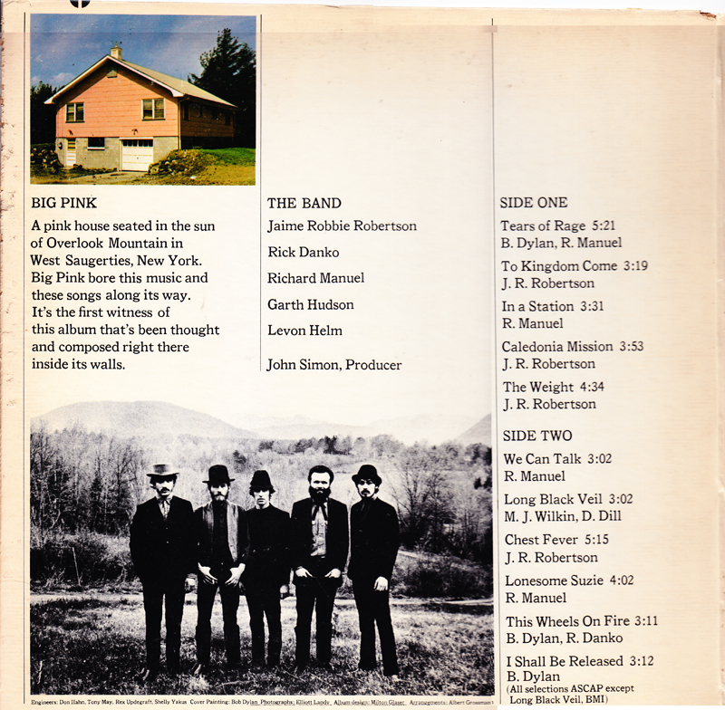
It features with most of the band members wearing old-fashioned hats (from RIchard Manuel's hat collection) and what seems like 19th-century riverboat gambler clothes (Rick's hat, Levon's vest, and Garth's black western string tie). In the background is a group of low mountains and directly behind them, a winding road. They are in a field above a small valley. Faint white smoke from a chimney can be seen in the distance at left, just above the forest. On the right, you can just barely see a white house in the woods in the far distance.) Garth has a home-made divining-rod (used to find water underground) in his hands. 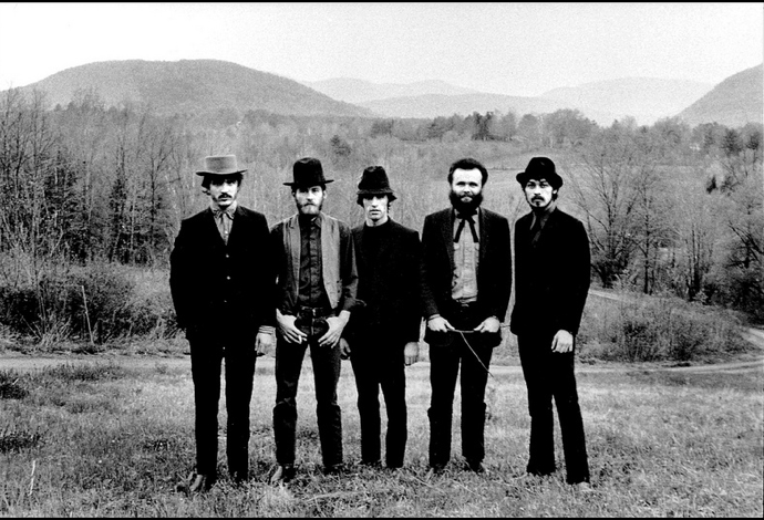
(Photo by Elliott Landy) Another outtake from the session was also used on a cover of a Band compilation album sold recently at Starbucks. In this shot you can also see the pedigreed German poodle named Hamlet that Bob Dylan gave to the band to keep at Big Pink when Dylan's house got too small for both Hamlet and Dylan's huge Saint Bernard named Buster. 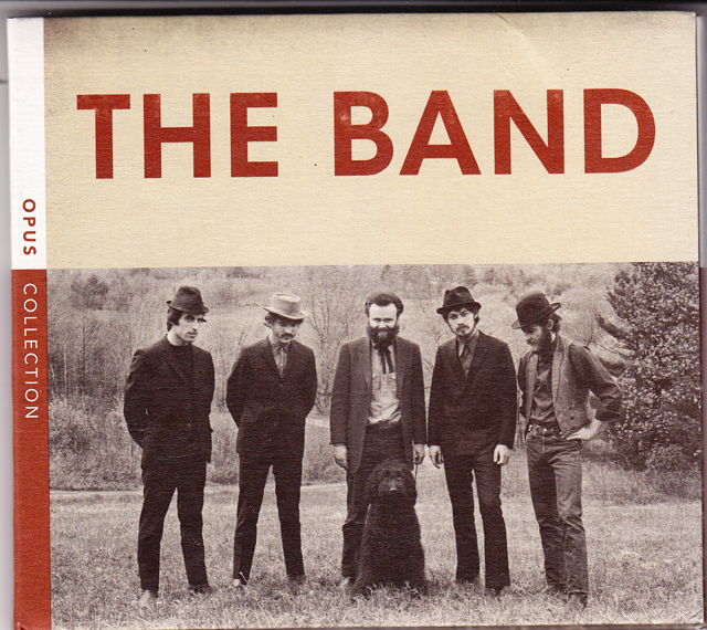
(Photo by Elliott Landy) Well, I finally tracked down the house, after about 3 months of weekend searching using overhead maps and a variety of directories. But as you'll see, I almost had it at my first guess. The big surprise - and what kept me from finding it right away - was that the "Wittenberg Road House" is no longer on Wittenberg Road -- it's on West Ohayo Mountain Road. Even though it hasn't moved! What happened was that the owners seemed to have sold part of the property (in the photo, at right) for people to build next door; and it made more sense to close off the old entrance -- the winding dirt road behind The Band -- and make a new driveway from a different road - a road I never bothered to look for the house on -- since it was not Wittenberg Road!. 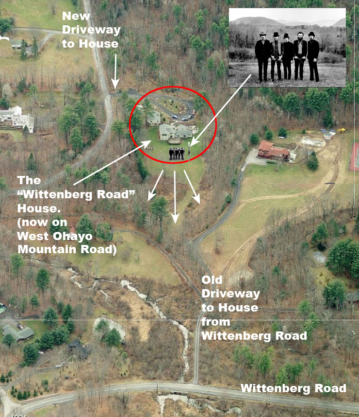
(Insert photo by Elliott Landy) The old, curvy, question-mark-shaped entranceway from Wittenberg Road is pictured off to the left in the black-and-white photo below. A dotted line shows where it would be today. 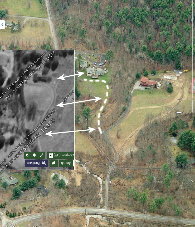
(Photo by HistoricAerials.com) Since the field where the band was standing is on private property, I can't superimpose the picture on an actual picture of the background. But, by using Google Earth, I can simulate what the background would look like, in this case, basically if I were standing on the roof of the house. Note how the mountains in the background all pretty much line up. (The view is looking north, past the town of Bearsville, with Mount Guardian off to the right.) 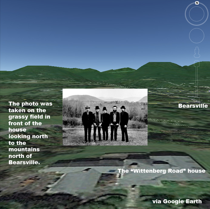
(Insert photo by Elliott Landy) To simulate what it would look like from ground level, I used Google Street view to go to West Ohayo Mountain Road, just about 1/10 mile up from the house. Note how how the mountains in the background match up in real life. 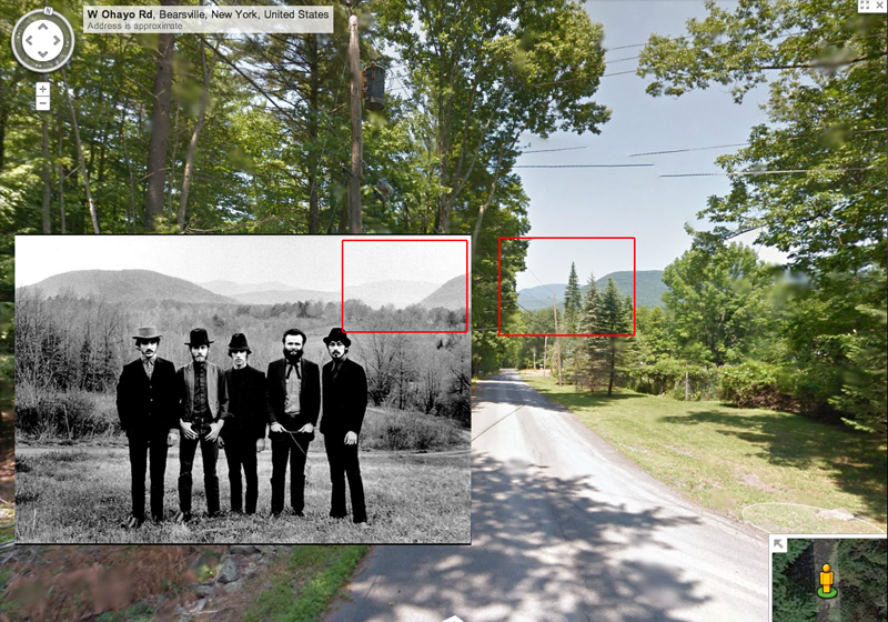
(Insert photo by Elliott Landy) And here's where that is on a topographic map. You can see the slope of Mt. Guardian to the right. If you see the word "Byrdcliffe" on the right -- that's where Dylan's house was. 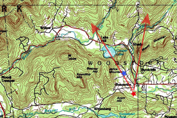
And here are the three sites where "The Basement Tapes were recorded, to put it all in perspective relative to the town of Woodstock. (Historical note: The Woodstock Festival (1969), named after the town of Woodstock, was actually held in the hamlet of White Lake, a part of the town of Bethel, New York, 68 miles by car southwest of Woodstock. The Band played for about an hour at 10 p.m. on Sunday, following Ten Years After, but was not in the movie.) 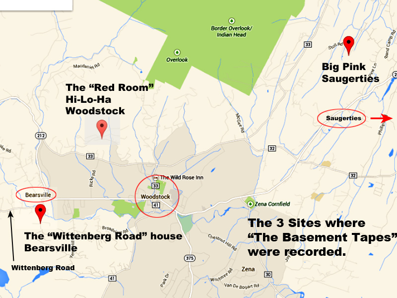
How I went about searching for "The Wittenberg Road" house. I had first heard about the "Wittenberg Road" house from reading probably the most extensive account of the recording of the Basement Tapes, Sid Griffin's MILLION DOLLAR BASH. (Griffin, a musician himself with the Coal Porters, also wrote the history of the tapes for the liner notes to the new CD release of the Basement Tapes,) 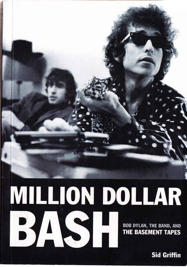
(Book cover photo by Jan Persson) In his book he mentions the "Wittenberg Road" house three main times, none of which give an exact address: 1) (page 107) "The sessions probably begin in March that year, starting as rehearsals and then recording. These were at Dylan's house, Hi Lo Ha, in Byrdcliffe, lasting into April, and possibly to early or mid May. Then Dylan and the Hawks shifted to Big Pink on Stoll Road (ed: now renamed Parnassus Road), working on and off until October 1967, and then moved again to Danko's house off Wittenberg Road. The sessions may have lasted until December, possibly even in to new year of 1968." 2) (page 227) "When Levon Helm arrived....Danko had to find a new place to snooze unless he wanted a bearded roommate...so Helm and Danko moved to a home on nearby Wittenberg Road (N.Y. State Road 45) that Danko had stumbled across just southwest of Grossman's Bearsville homestead. Hudson and Manuel moved out as well to a crib off Ohayo Mountain Road....These new homes were only five miles from Big Pink." 3) (page 236) "When Helm, Danko, Manuel, and Hudson moved out of Big Pink there was no way the sessions could continue in the basement there: the guys lived elsewhere. Helm and Danko were near Wittenberg on the road toward Bearsville, Manuel and Hudson not far off Ohayo Mountain Road. The rhythm section somehow won the toss of the coin and the Wittenberg Road pad became the new recording location." His book also includes a map to the Basement Tape houses, but the house the illustrator draws for the "Wittenberg Road" house does not match the Landy picture. It is, rather, a copy of a real house as seen from Bing's Bird's-Eye-View in a location along Wittenberg Road that is an approximate guess to the actual location (since I don't think they knew the location.) 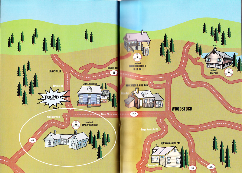
(Map from MILLION DOLLAR BASH) Another book that mentions the "Wittenberg Road" house, but does not give an address (probably because it had a rural route box # along Wittenberg Road) is Levon Helm's autobiography, THIS WHEEL'S ON FIRE. (This Wheel's on Fire: Levon Helm and the Story of the Band, by Levon Helm with Stephen Davis, 1993, William Morrow) 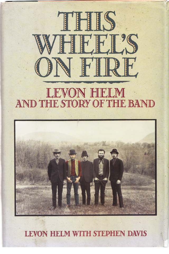
(Cover photo by Elliott Landy) In a caption to an out-take photo from the "Civil War" photo, Levon writes: "The Big Pink group photo was taken at a house Levon and Rick were renting at nearby Wittenberg, New York, spring 1968. Our dog Hamlet, a gift from Bob Dylan, was present at the creation." Here's the picture from the book: 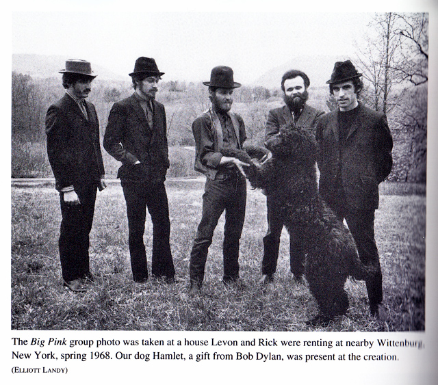
(Photo by Elliott Landy) While we are at this location, here's another clue I had to the location: a color out-take from Elliott Landy's photo shoot. It shows the curving road behind them, starting to curve in the other direction way in the background. (Sidenote: According to Levon in his book, the reason the band is smiling in this specific shot is because "the young wife of a friend of Garth's tore off her dress and did a naked little...hippie dance" just off camera. For proof, there's a photo of the scene at Elliott Landy's website.) 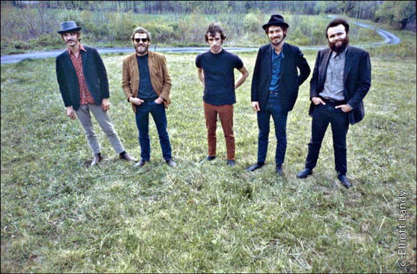
(Photo by Elliott Landy) Another out-take shows up on a video documentary of The Band*, and in that, as the camera pans past Rick, in the background we can see a white house. This will later be helpful in identifying the spot where the photo was taken. *(The Band - Classic Albums - Eagle Rock Entertainment) 
(Photo by Elliott Landy) But the primary clue as to the location of the house, was a photo of the house itself. This photo, also by Elliott Landy, shows Levon next to the house (and captioned as being "in the backyard" of the house). More important to me was the location of the roofs and the chimneys. This will be key in matching the house later. 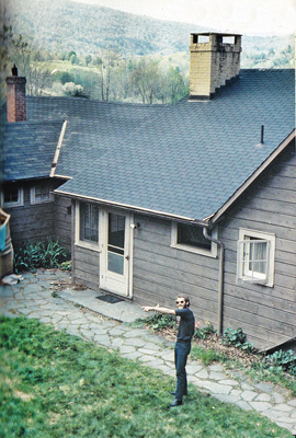
(Photo by Elliott Landy) And speaking of the house, one final clue, Elliott Landy wrote that the "Civil War" shot was taken outside this window of the "Wittenberg Road" house, found in one of his photos. (If you remember back to the "question mark shaped" driveway from earlier, this would have been right next to it, outside their house.) 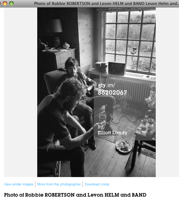
(Photo by Elliott Landy) So now I had all these clues, I started to look for the house. First, I found a map of Wittenberg Road. It extended from Bearsville west to Wittenberg. I also looked for the curvy road behind them. 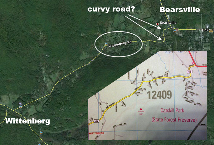
So I went to Google Earth and "flew" over two spots where the road curved sharply (you'll see the photo below). Of the two, one lower on the mountain looked the most promising. And, when I hovered over the curve in the road, then "tilted" Google Ea2rth up to see the horizon -- the mountains seemed to match. 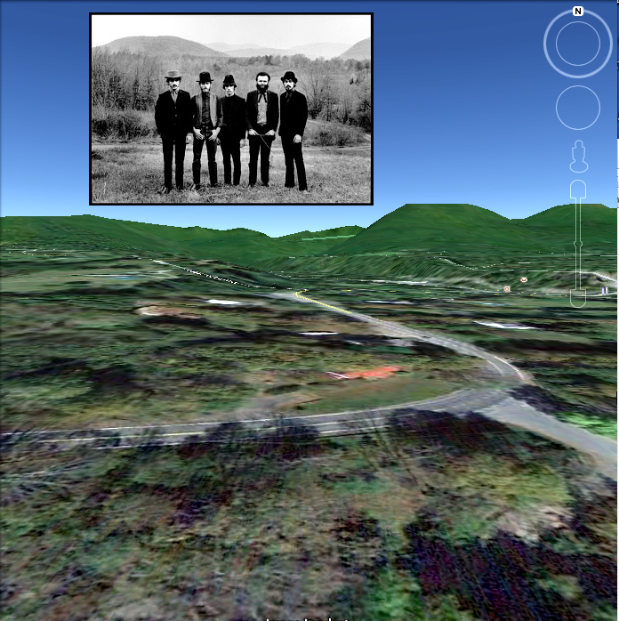
(Insert photo by Elliott Landy) But when I looked down closer, spot #1, on Wittenberg Road, didn't match the photo of the house with Levon in it. And even spot number 2, with the same curve, but a block up the mountain, didn't work since there was a big white house where the field would be. There were too many other houses in the background. (House #1 by the way, was the model for the house used in the illustration in the book Million Dollar Bash that I showed earlier. 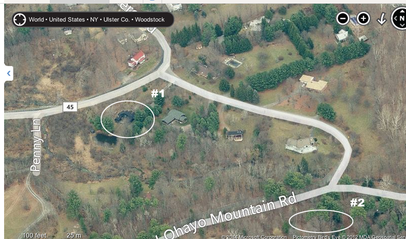
And basically, that's the way it went for the next few months. Using Bing's Bird's Eye View and Google, I would "fly " over the houses on Wittenberg road looking for a match. I used topographic maps of Bearsville and Wittenberg... 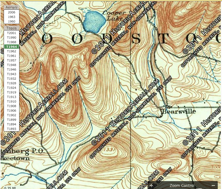
...old aerial maps from the 60's... 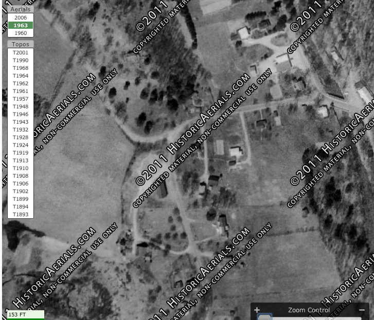
...I got a Catskills Forest Ranger to mock up an elevation map for me... 
...and I even found a letter on Ebay addressed to Rick Danko's post office box (#434) from Dylan (albeit 1995). But none of these clues helped... 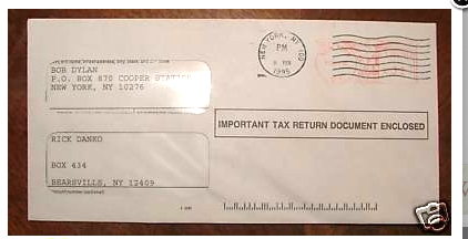
So finally, I went back to the place I originally thought it was and looked deeper. This time my eye caught house #3. It wasn't on Wittenberg Road. It was on West Ohayo Mountain Road. But, when I looked closer, the placement of the roofs and the two chimneys looked right. So I zoomed in. 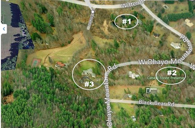
Everything matched! The roofs, the chimneys, the slate walkway and the window. The house had been modified, but this was definitely it. And it also answered the question of how Elliott Landy had photographed Levon from so high up: he was probably standing on the roof of the garage just to the right of the green arrow in the left picture. But why did did everyone in all the books refer to it as being on Wittenberg Road? And where was the curvy road behind the Band? 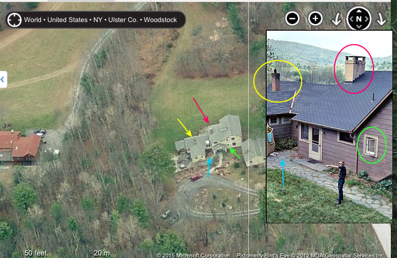
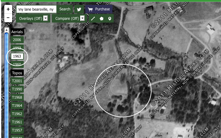
(Insert photo by Elliott Landy.) For that, I had to go back in time, to see what the layout of the neighborhood used to look like around when the photo was taken in 1968. So I found the site on an overhead shot from Historic Aerials (www.historicaerials.com) from 1963. In the photo you can see that the curved driveway begins on Wittenberg and goes right up to the front door. (Note: the difference in height from Wittenberg Road to the house, which is partway up Ohayo Mountain, is about that of a 7-story building.)
Furthermore, as you can see from the inset on top of the next photo, if the Band were standing on spot x and they were photographed with a telephoto lens, the long curve behind them would be foreshortened to the way we see it in the photo. 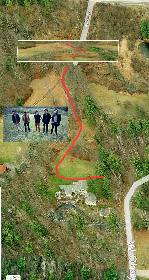
(Insert photo by Elliott Landy.) So what happened, as we can see below, was that when another house was built to the left of the "Wittenberg Road" house, they were given the driveway from Wittenberg for themselves, and the "Wittenberg Road" owners let the grass grow over the old road. 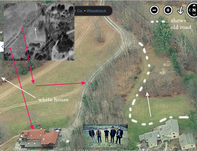
(Insert photo by Elliott Landy.) And remember the white house we saw earlier in the woods in back of Rick? Here it is. 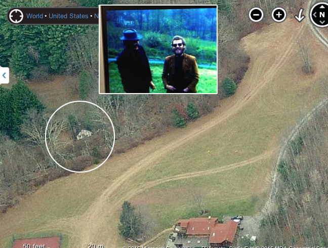
(Insert photo by Elliott Landy.) Here's an interesting side fact. After I found the house, I was reading through Levon's book again and came upon a chapter that his former wife, Libby Titus, wrote. In it, she writes: (p.183) "Levon and Rick were living in the Cabbott house, a dusty and sexy little cowboy house off the Wittenberg Road." I had missed that little nugget, because "Wittenberg Road" is not in the extensive index of the book. So I called up the women at the town clerk's office in Woodstock who had been answering questions for me and asked if the house I had spoken to her about halfway up West Ohayo Mountain Road used to be called the Cabbott House. And I spelled it out. "Why, yes," she said, "the woman who owned that was very famous around here. But it's spelled C-A-B-O-T. So I found out who she was: Petra Cabot. And it turns out she was a industrial designer who invented the Skotch Kooler, an insulated container to keep food cold on picnics that was sold all over the US in the 1950's. My family even owned one. Here's a picture of Petra and her product. And a color shot from Etsy. 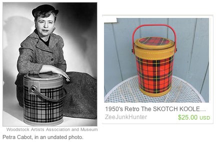
The place where most of the Basement Tapes were created is the house The Band called Big Pink, located on 56 Parnassus Road in Saugerties, N.Y.. (The street named has been changed: The address when Garth, Rick, and Richard lived there was 2188 Stoll Road. In this shot from Flickr, you can see the place looks pretty much the same today as back in The Band years. 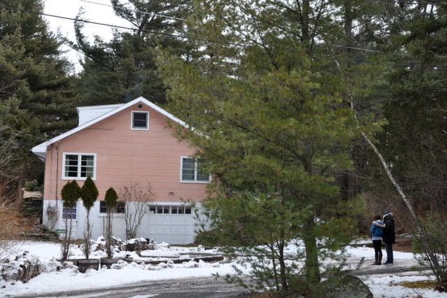
And in another shot from the web, you can see how big the basement was - enough room for 6 musicians, assorted dogs, and a tape recorder. These walls have been stripped of wood down to concrete. I'm not sure what the walls were like when Bob and The Band were there. 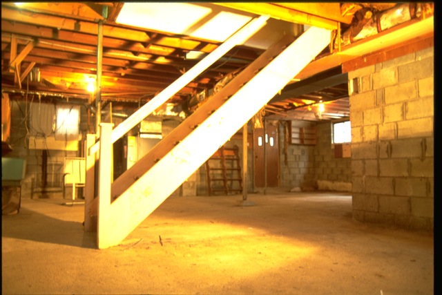
Here it is from the opposite angle. In the back you can see the entrance door that leads out to the driveway. Those photos are from the present owners' website: www.bigpinkbasement.com . Check it out for more photos. 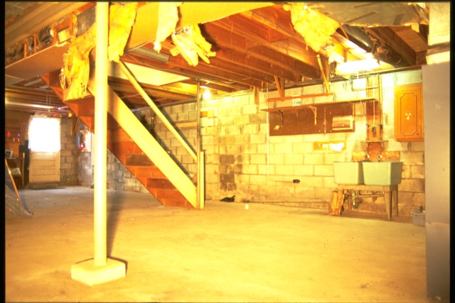
You can get a sense of what it looked like when Dylan and The Band were recording into the reel-to-reel in this shot of the equipment of the Woodstock area musicians called Just Julie taken recently in the basement by Mark Delf (and found on Twitter). 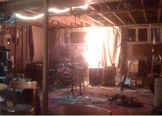
Here's another look at the front and back cover of Music from Big Pink. In his book Levon says the cover painting, by Bob Dylan, could depict the five musicians of the Band (then known as The Hawks) and a roadie. The "roadie" figure, the only one without an instrument, might also be their longtime producer, John Simon. Perhaps Bob himself, is the proverbial "elephant" in the room. And maybe that's an "apple suckling tree, oh, yeah" in the back. 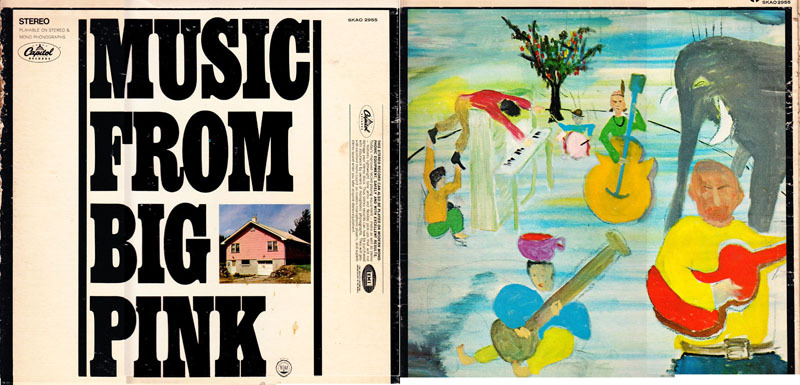
The cover was designed by Milton Glaser, famous for also designing the "I (Love) NY" logo... ...and also the iconic poster of Dylan that came in the first Bob Dylan's Greatest Hits album (1967)... 
..which was based on a 1957 silhouette self-portrait by Marcel Duchamp that Duchamp had cut out of paper, combined with a kaleidoscope of psychedic hair based on "certain forms of Islamic painting." 
Recently "Mad Men" paid homage to it in their ads, as the story line entered the middle of the swingin' sixties. 
The inside of the album cover has the famous photo of The Band and their extended families. The photo, known as the "Next of Kin" photo because those words are on the left side of the picture, was also taken by Elliott Landy. It is widely known to have been taken on Rick Danko's brother's farm near the town of Simcoe in the province of Ontario, Canada. (All the Band member were from the province of Ontario, Canada, except for Levon Helm who came from Arkansas.) 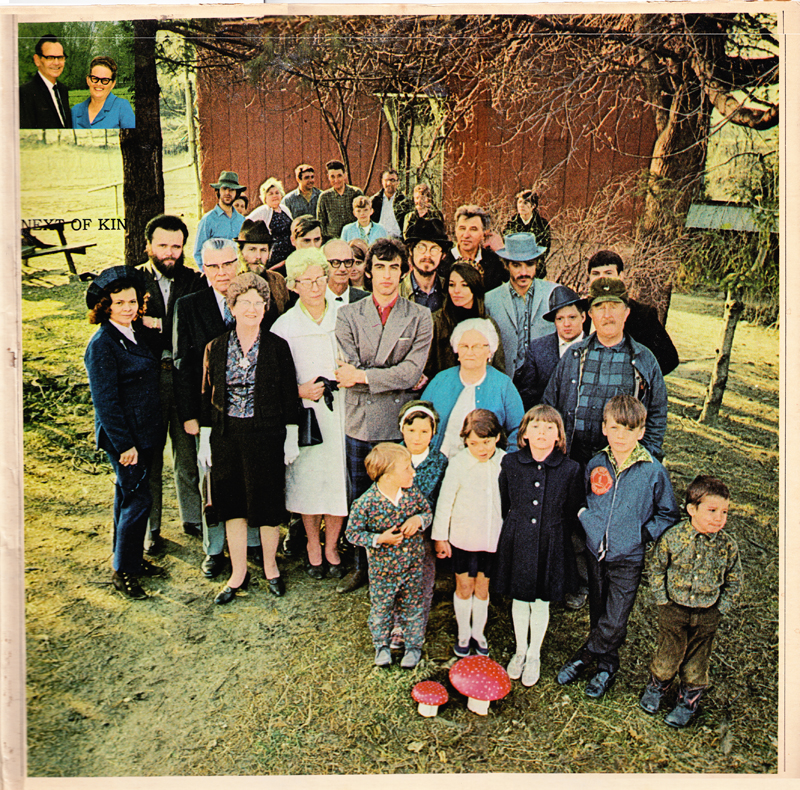
(Photo by Elliott Landy.) To track down the location of the shot, I first searched the web and found other out-takes from the same shoot. Most noticeable in this one were the three windows on top of the red barn behind them. 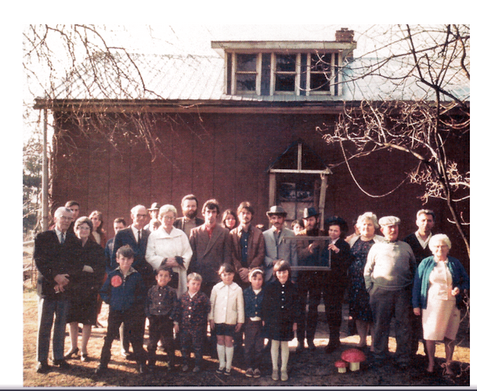
(Photo by Elliott Landy, via Marie Fotini of France) Next, knowing that the photo had been taken on "Rick's brother's farm," I had to figure out which one. I found that Rick had three other brothers: Dennis, Terry, and Maurice, Jr. (Terry is a musician. This is from his Facebook page.). 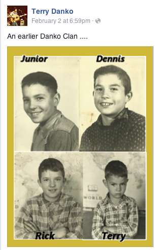
I figured the farm belonged to Maurice, Jr., who, through Googling, I had discovered was associated with tobacco farming and harness racing. He also had the only address in the area around Simcoe: Rural Route #6, N3Y 4K5, Simcoe, Ontario, Canada. A Rural Route number gives no specific address; the postman just puts the mail in the boxes along his route. The address, however, did include a Canadian postal number, the equivalent of an American Zip Code. The postal number was N3Y 4K5 and, by putting that into Google, I got a map of the postal area, which I superimposed over a map of western Simcoe. 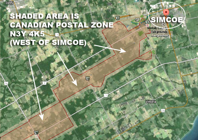
I also knew that Rick Danko had grown up around several tiny towns -- virtual crossroads - in the same area: Blayney and Greens Corners. So I looked around them too. Here's a recent sign that the Norfolk County tourist board put up in honor of RIck outside Blayney. 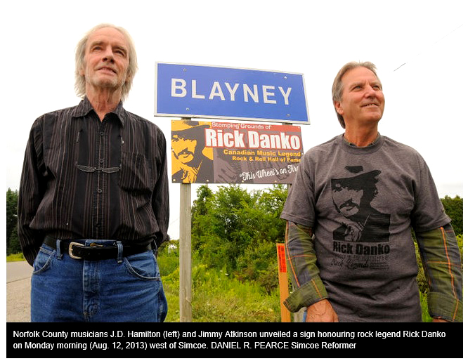
So my next step was to search through this area for a farm that could grow tobacco and had a horse track on it, for exercising the horses. So after many passes up and down the various farms with Google Maps and Bing's Bird's-Eye-View, I found a farm with a horse track, but more importantly, it had this group of buildings (below), because the one with the arrow pointing to it had shape of the roof taken up by the three windows in the "Next of Kin" photos. 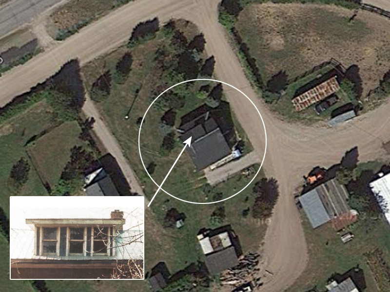
So then I found the same spot on Google Street view and came to this, the entrance to the farm. (Note: at this point Marie Fotini, my France-based PopSpots associate, was helping in my search and came up with some alternate pictures, like this one) 
And right behind that was the building with the three windows on the roof -- and it matched! (note: you can just barely see a person between the evergreens; a relative of Ricks?) 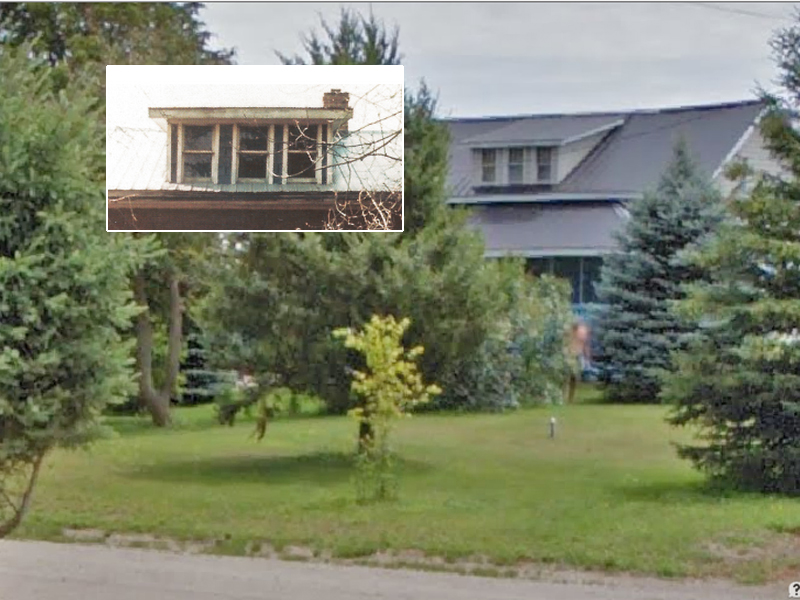
So, I superimposed the album "Next of Kin" photo with the modern one to combine the old and new. 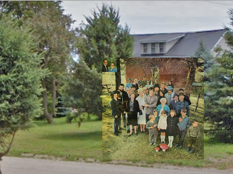
(Insert photo by Elliott Landy.) Now let's look at some other Band album cover locations. First, the cover of the second Band album called THE BAND. It was also taken by Elliott Landy. 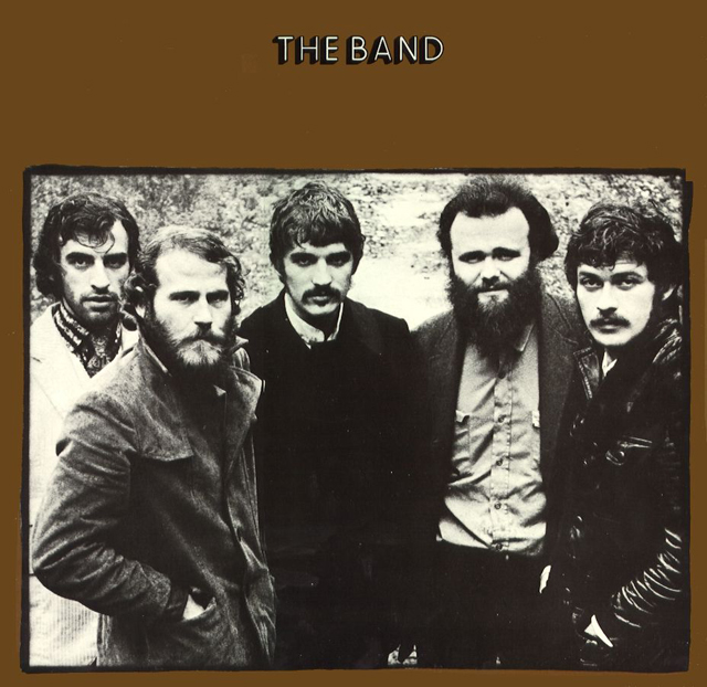
(Photo by Elliott Landy.) It was taken along bucolic John Joy Road in Zena, a small hamlet near Woodstock. 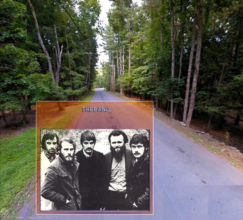
(Insert photo by Elliott Landy.) The photo on the back cover of the album, also by Elliott Landy, shows the Band practicing in the basement of the house Rick rented after he left the Wittenberg Road house. 
(Insert photo by Elliott Landy.) There's also a photo from inside the album of Robbie and Levon practicing in one of Rick's upstairs rooms 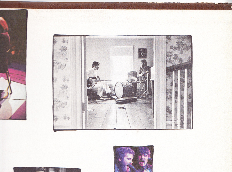
(Insert photo by Elliott Landy.) According to a local historian, Rick's house was on Zena Road "past the red barn." 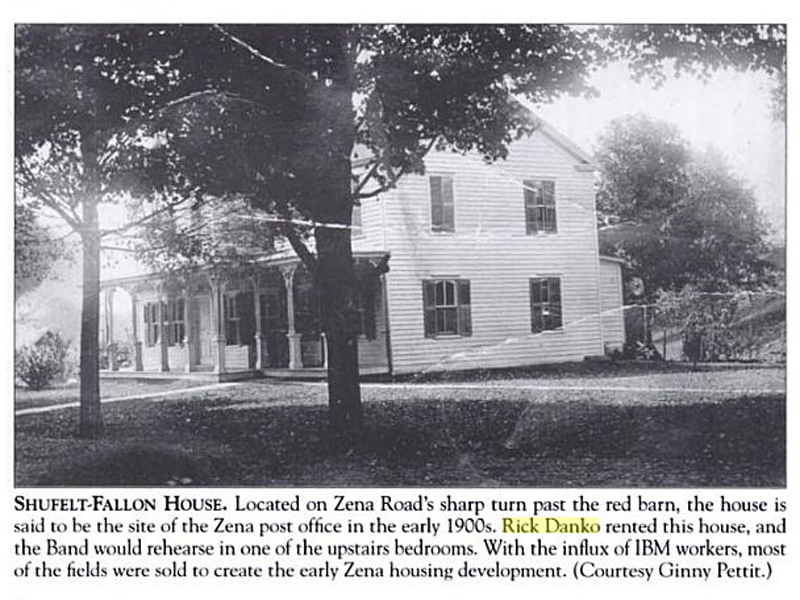
That house would be this one, I found by finding the big curve on Zena Road, then the big red barn, then this. It looks a little different from the black and white shot, but mostly because they screened in the front porch. 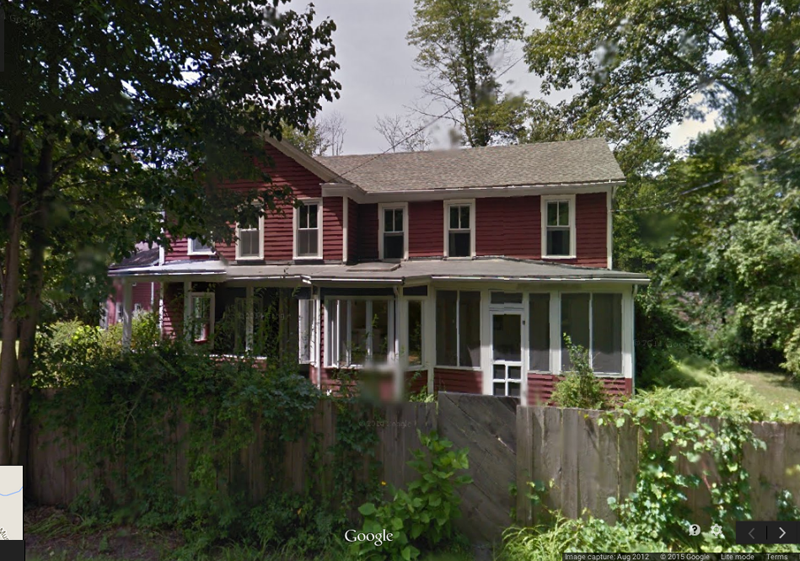
Here's what the road looks like. On Google Maps search for 448 West Hurley-Zena Road. That gets you to this shot, but the actual address is 373 Chestnut Hill Road, Woodstock, as the driveway is up the road on the right in the distance. 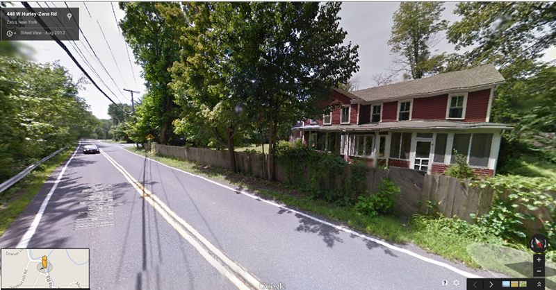
Here's a picture of the inside. You can see more shots of the inside if you Google the address and look at photos on the real estate websites. The building is sometimes offered for rent. 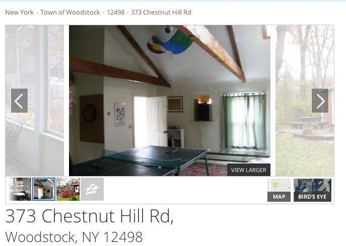
While we're looking at Woodstock houses, let's take a look at the house near Woodstock that Garth and Richard rented, after Levon arrived from a year away and rented the "Wittenberg Road" house with Rick. Basically, in the time after most of the Basement Tapes were finished The Band would gather up here and practice together for their next album, somewhat continuing the spirit of the Basement Tapes sessions. The house they rented was on Spencer Road, a mountaintop road way up on Ohayo Mountain Road, south of Woodstock. From their backyard they had great views of the Ashokan Reservoir. (Their house was second to last on the right side of the rod.) 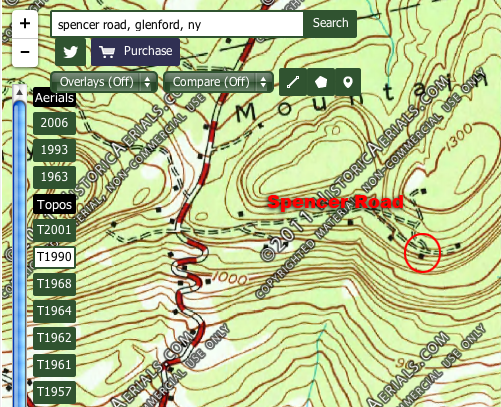
Here's a group shot of the band in the backyard, superimposed over a shot from a real estate website of a house for rent on the same road. 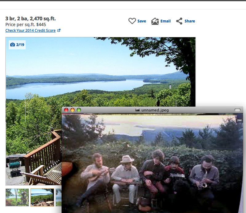
(Insert photo by Elliott Landy.) The most familiar shot from this well-known series of photo by Elliott Landy is this one. Make note of that fence in the background and also the little extension to the white roof on the right. 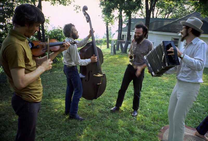
(Photo by Elliott Landy.) After Garth and Richard left this house, Van Morrison rented it and had a lot of the photos for his album Van Morrison - His Band and the Street Choir" taken outside. 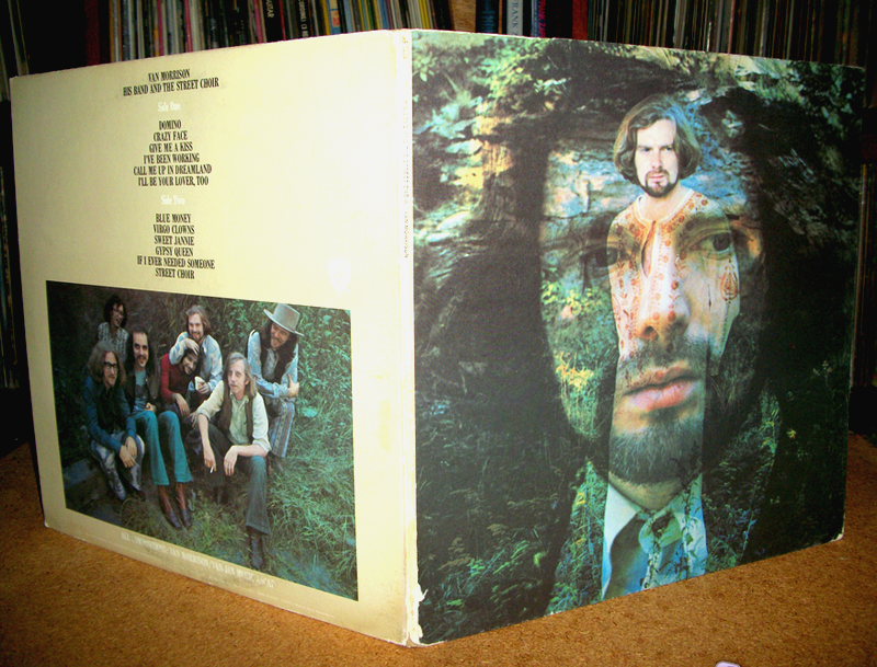
(Cover photos by Elliott Landy.) Here's a shot from the inside sleeve of one of the musicians - John Platania* - in front of the fence we saw earlier. (*thanks, Mick Leahy) 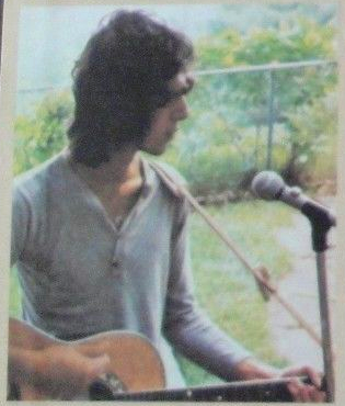
(Photo by Elliott Landy.) And here's Van himself in from of the white house extension I had you note, too. (In a composite by Marie Fotini, a PopSpots researcher from France.) 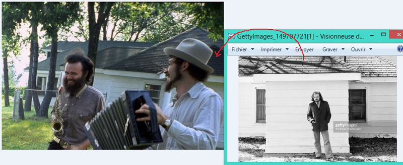
(Photos by Elliott Landy.) You can see how all the roofs match up in this aerial shot looking down at the end of Spencer Road. 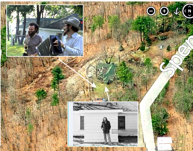
(Insert photos by Elliott Landy.) Here's a shot of guys mixing it up in the house on Spencer Road, just like back in the basement of Big Pink (but way higher). 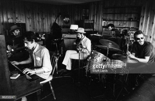
(Photo by Elliott Landy.) The reason I bring this up is because there is mention in some writings about The Basement Tapes that The Band recorded some of the Basement Tapes at the home of Clarence Schmidt on Spencer Road. I think they really mean this house, which was not owned by Clarence Schmidt. Clarence Schmidt was an eccentric "outsider" artist who owned a plot of land at 84 Spencer Road, down the road from Garth's house, and between 1940-1972 built two wild, patchwork houses on the land, known collectively as "Miracle on the Mountain." First, with a log cabin as its core, using found objects, old window frames, and roofing tar as glue, he built The "House of Mirrors" seen below, which burned in January of 1968. This does not seem like the place where The Band would pay their instruments, with Garth's house just down the road. (Note: there is nothing left of Clarence's creations and new owners have built a new home in its place.) 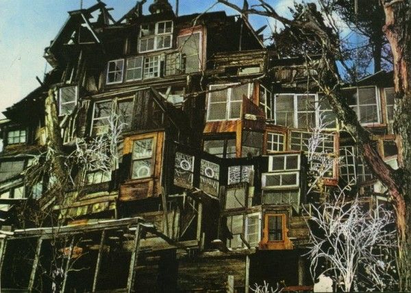
A year later, he made another structure on the land, which he called Mark II, with paths lined with the broken dolls extending out from the core of a Studebaker station wagon. This would burn down in 1971. Here's a photo of Clarence. His work captured the imagination of the art world for a while and during the 60's was he profiled about in national magazines like The Saturday Evening Post and Horizon. 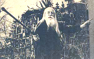
Here's another shot of Clarence, this time with Van Morrison, who must have wandered down Spencer Road for a look at Clarence's creations. 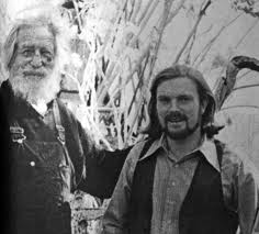
The next Band album I want to take a look at it Cahoots from 1971. The cover art was created by the artist Gilbert Stone who likes to paint his subjects somewhat compressed. 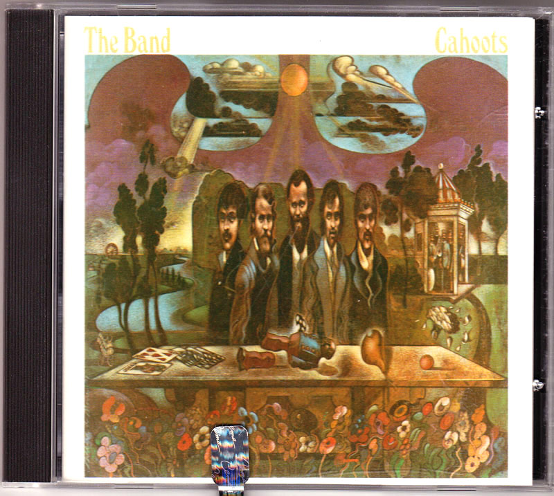
Just for fun I thought I'd "decompress" the illustration to see what the guys looked like before the funhouse mirror effect. It looks like on the the "Sergeant Pepper-like" musicians from the back right carousel broke a leg and is on the table in front of them. 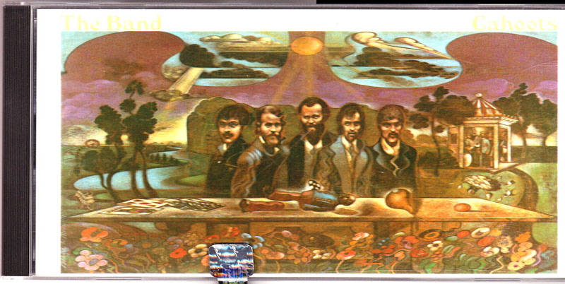
The album after Cahoots was Moondog Matinee from 1973, named after Alan Freed's pioneering rock and roll radio show from Cleveland called "Moondog Matinee." On it The Band covered 10 of the favorite songs they used to play when they were in a touring band with Ronnie Hawkins, who they later invited to play at their "Last Waltz" farewell concert. The album inner gatefold is by the artist Edward Kasper. The Band used to play in the Cabbagetown neighborhood of Toronto and Robbie described the look and feel of the place to the artist who then made the cover. 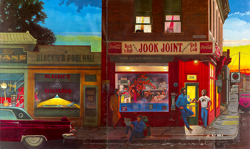
(ALbum interior illustration by Edward Kasper.) He must have seen some photos because the actual place, Cabbagetown in Toronto, looks very similar in this side by side comparison. 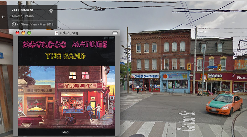
I'd like to wind this look of The Band covers up with two albums by Robbie Robertson. The first, is his first solo album from 1987. 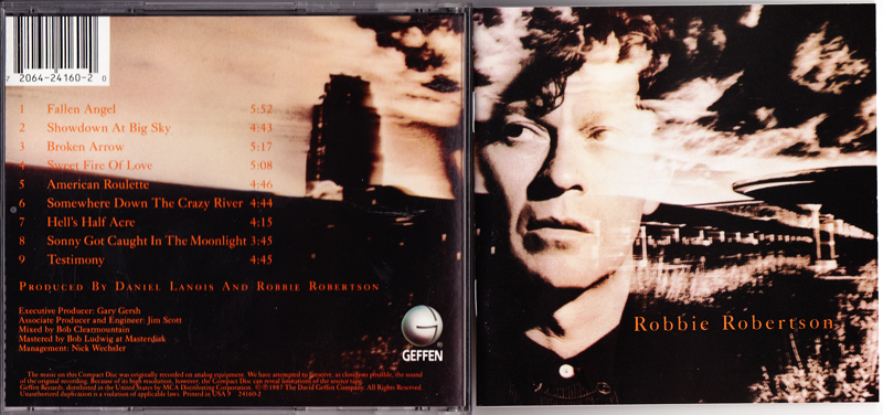
(Photo of Robbie Robertson by Chris Callis.) The background photo is of the abandoned art deco "Buffalo Central Terminal" train station in Buffalo, New York, which I image Robbie passed through on trips south from Ontario. (The image is from moreintelligentlife.com) 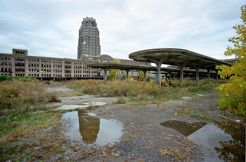
And here the album is PopSpotted in its exact location. 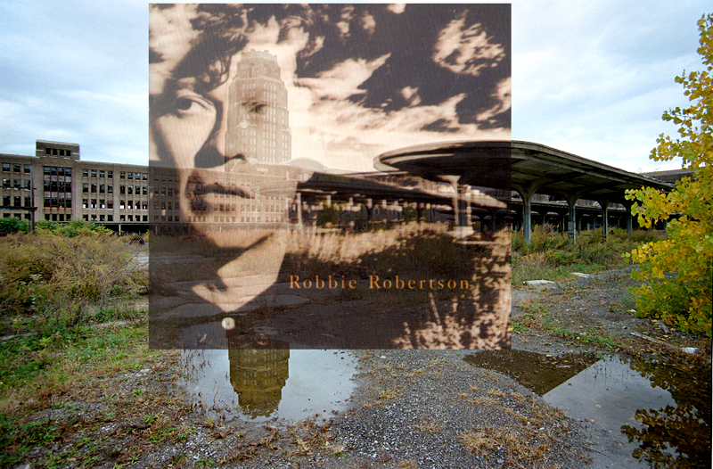
(Insert photo of Robbie Robertson by Chris Callis.) The last album we are going to look at is Robbie Robertson's Storyville from 1991. Storyville was the red-light district of New Orleans from 1897 through 1917 and one of the birthplaces of jazz. The album cover photo is by Sydney Byrd. 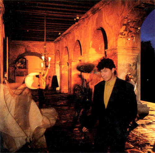
(Cover photo by Sydney Byrd.) The cover photo was taken in this building called the Cabildo (City Council), which is alongside Jackson Square in New Orleans. The building was completed in 1799 and used as the colonial seat of government for Spain. (Note: here's a shout-out to my kids Alice and Nick, who both went to college in New Orleans, for helping Dad find this spot during a visit.) It was the site of the Louisiana Purchase transfer ceremonies in 1803. 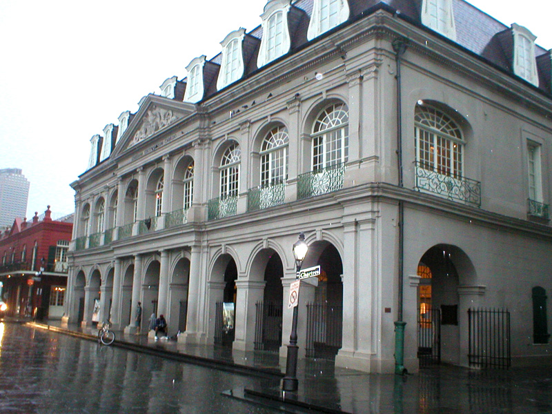
The photo was taken inside these Spanish arches. 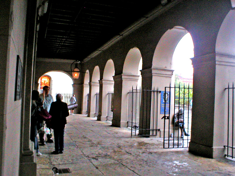
And here's the cover PopSpotted. And with that, as the Spanish say, I bid you adios! See you up on Cripple Creek. 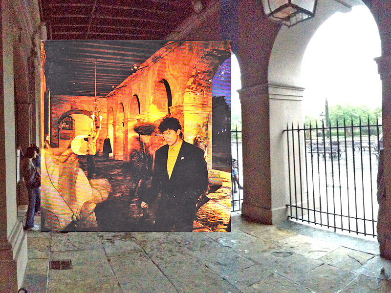
(Insert cover photo by Sydney Byrd.) (Once again, click here to get to Elliott Landy's website, LandyVision, where he has hundreds of photos of 60's rock performers and the Woodstock festival available for purchase. While there, you may want to join his Kickstarter campaign to turn his 8,000 never-before-seen photos of The Band into a book.) ALSO PLEASE SEE THE ADDENDUM BELOW FOR ADDITIONS TO THIS ENTRY. 
ADDENDUM #1 This PopSpots reader named Scott T stayed in the "Wittenberg Road" house" over New Years Eve in 1978. (Thanks, Scott, for sending this in. - Bob/PopSpots) Hey Bob, For what its worth, my name is Scott Thompson, living in Fla. and I am a teacher. I enjoyed your article today about Wittenberg Road house. I spent the last week of 1978 and New Years '90 at that house. My girlfriend's mother was living there at the time. I am pretty sure she owned the property. She was a divorced NYC artist who received the house after her divorce. She had set up a video commune there in the 70s. The living room window looked out at the landscape that is pictures with the band. They had the Landy pic framed on one side of the bay window, and a family pic, similar to the Landy pic, framed on the right side of the window. Also, one morning in the back of the house (Levon pic) while I was having a cup of coffee, a man came out of the back building (a rented apartment), and he looked just like Gilligan from the tv show. It blew me away. In fact it was Bob Denver's son who was living there with his Mom. So, just thought I could pass on a little more info. And yes there was a long driveway coming up the property. Talk soon, Scott |
||